Critical Habitat of the Lake Chubsucker (Erimyzon sucetta) Order (SOR/2018-156)
Full Document:
- HTMLFull Document: Critical Habitat of the Lake Chubsucker (Erimyzon sucetta) Order (Accessibility Buttons available) |
- XMLFull Document: Critical Habitat of the Lake Chubsucker (Erimyzon sucetta) Order [20 KB] |
- PDFFull Document: Critical Habitat of the Lake Chubsucker (Erimyzon sucetta) Order [12268 KB]
Regulations are current to 2024-06-11
SCHEDULE(Section 2)
TABLE 1
Coordinates of the Areas Within Which the Critical Habitat of the Lake Chubsucker is Found
Column 1 | Column 2 | Column 3 | Column 4 | Column 5 | |
---|---|---|---|---|---|
Item | Location | Point 1 (NW) | Point 2 (NE) | Point 3 (SE) | Point 4 (SW) |
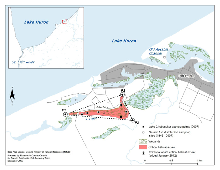
1 | L Lake | Latitude 43°13′27.490″ N, longitude 81°55′17.517″ W | Latitude 43°13′40.029″ N, longitude 81°54′29.740″ W | Latitude 43°13′24.085″ N, longitude 81°54′20.904″ W | |
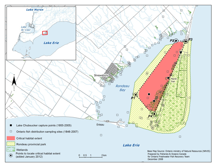
2 | Rondeau Bay | Latitude 42°16′58.396″ N, longitude 81°53′50.301″ W | Latitude 42°19′34.763″ N, longitude 81°51′19.993″ W | Latitude 42°19′32.256″ N, longitude 81°50′42.122″ W | Latitude 42°16′03.673″ N, longitude 81°52′40.250″ W |
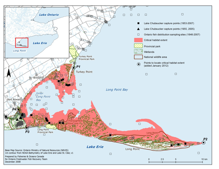
3 | Long Point Bay | Latitude 42°40′45.822″ N, longitude 80°19′57.794″ W | Latitude 42°33′04.619″ N, longitude 80°02′20.594″ W | Latitude 42°34′43.393″ N, longitude 80°26′24.629″ W | Latitude 42°36′36.151″ N, longitude 80°27′31.869″ W |
MAPS
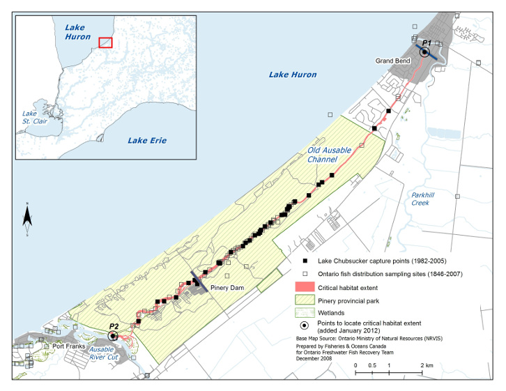
Map 1: Critical Habitat of the Lake Chubsucker Within the Old Ausable Channel
![Map 1 is a map of the portion of Lake Huron’s south-eastern shore that surrounds the Old Ausable Channel. The extent of the Lake Chubsucker’s critical habitat is illustrated and includes the length of the Old Ausable Channel from its mouth, denoted by the point P2, to its end at Grand Bend, denoted by the point P1. The map indicates Lake Chubsucker capture points (1982–2005) as well as Ontario fish distribution sampling sites (1846–2007). A smaller scale map including the area depicted by Map 1 and its surroundings is inset at the top left corner.](/images/SOR-2018-156img/SOR-2018-156_e001.jpg)
Map 2: Critical Habitat of the Lake Chubsucker in L Lake
![Map 2 is a map of a portion of Lake Huron’s south-eastern shore, inland to L Lake. Three points, namely, P1, P2 and P3, form a triangle on the map within which the extent of the Lake Chubsucker’s critical habitat is illustrated for L Lake. The map indicates Lake Chubsucker capture points (2007) as well as Ontario fish distribution sampling sites (1846–2007). A smaller scale map including the area depicted by Map 2 and its surroundings is inset at the top left corner.](/images/SOR-2018-156img/SOR-2018-156_e002.jpg)
Map 3: Critical Habitat of the Lake Chubsucker in Rondeau Bay
![Map 3 is a map of the portion Lake Erie’s north shore that surrounds Rondeau Bay and Rondeau Provincial Park. Four points, namely, P1, P2, P3 and P4, form a quadrangle on the map within which the extent of the Lake Chubsucker’s critical habitat is illustrated. The critical habitat is located within Rondeau Provincial Park and is bounded on the east side by Marsh Trail. The map indicates Lake Chubsucker capture points (1955–2005) as well as Ontario fish distribution sampling sites (1846–2007). A smaller scale map including the area depicted by Map 3 and its surroundings is inset at the top left corner.](/images/SOR-2018-156img/SOR-2018-156_e003.jpg)
Map 4: Critical Habitat of the Lake Chubsucker in Long Point Bay
![Map 4 is a map of the portion of Lake Erie’s north shore that abuts Long Point Bay, Long Point and Turkey Point. The extent of the Lake Chubsucker’s critical habitat is illustrated and includes waters and wetlands that extend along Lake Erie’s shoreline from Turkey Point, along Inner Long Point Bay and out to the tip of Long Point. Four points, namely, P1, P2, P3 and P4, provide markers delimiting the area within which the critical habitat is located. The map indicates Lake Chubsucker capture points (1953–2007; 1955 and 2005) as well as Ontario fish distribution sampling sites (1846–2007). A smaller scale map including the area depicted by Map 4 and its surroundings is inset at the top left corner.](/images/SOR-2018-156img/SOR-2018-156_e004.jpg)
Map 5: Critical Habitat of the Lake Chubsucker in Lyons Creek
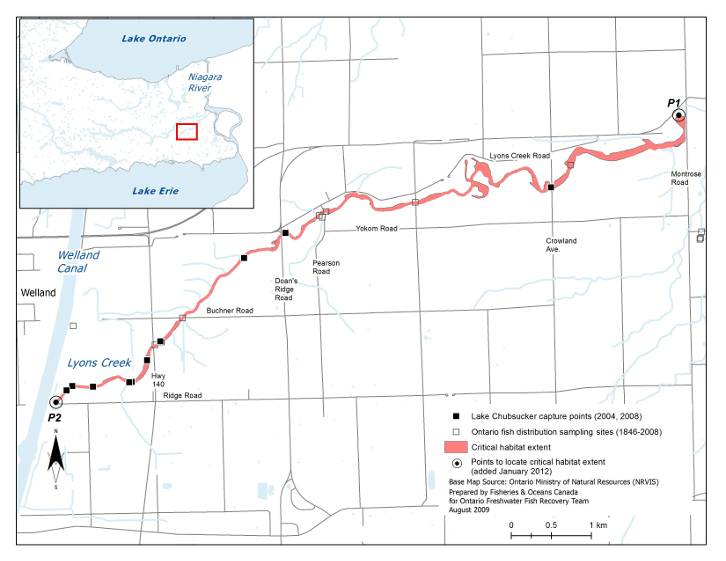
![Map 5 is a map of Lyons Creek. The location of the Lake Chubsucker’s critical habitat is illustrated and extends from the Welland Canal, denoted by the point P2, to Montrose Road, denoted by the point P1. The map indicates Lake Chubsucker capture points (2004, 2008) as well as Ontario fish distribution sampling sites (1846–2008). A smaller scale map including the area depicted by Map 5 and its surroundings is inset at the top left corner.](/images/SOR-2018-156img/SOR-2018-156_e005.jpg)
TABLE 2
Key Features and Attributes of Critical Habitat
Column 1 | Column 2 | Column 3 | Column 4 |
---|---|---|---|
Life Stage | Function | Features | Attributes |
Spawn to hatch | Spawning, cover, nursery | Areas that seasonally support aquatic vegetation |
|
Young-of-the-year, juvenile, adult | Feeding, cover, nursery | Areas that seasonally support aquatic vegetation |
|
- Date modified: