
Table of Contents
Critical Habitat of the Nooksack Dace (Rhinichthys cataractae ssp.) Order
SOR/2016-82
Registration 2016-05-02
Critical Habitat of the Nooksack Dace (Rhinichthys cataractae ssp.) Order
Whereas the Nooksack dace (Rhinichthys cataractae ssp.) is a wildlife species that is listed as an endangered species in Part 2 of Schedule 1 to the Species at Risk ActFootnote a;
Return to footnote aS.C. 2002, c. 29
Whereas the recovery strategy that identified the critical habitat of that species has been included in the Species at Risk Public Registry;
And whereas no portion of the critical habitat of that species that is specified in the annexed Order is in a place referred to in subsection 58(2) of that Act;
Therefore, the Minister of Fisheries and Oceans, pursuant to subsections 58(4) and (5) of the Species at Risk ActFootnote a, makes the annexed Critical Habitat of the Nooksack Dace (Rhinichthys cataractae ssp.) Order.
Ottawa, April 21, 2016
 Hunter Tootoo Minister of Fisheries and Oceans Le ministre des Pêches et des Océans |
Application
1 Subsection 58(1) of the Species at Risk Act applies to the critical habitat of the Nooksack dace (Rhinichthys cataractae ssp.), which is identified in the recovery strategy for that species that is included in the Species at Risk Public Registry.
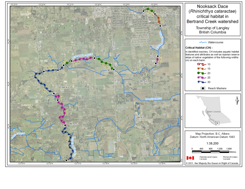
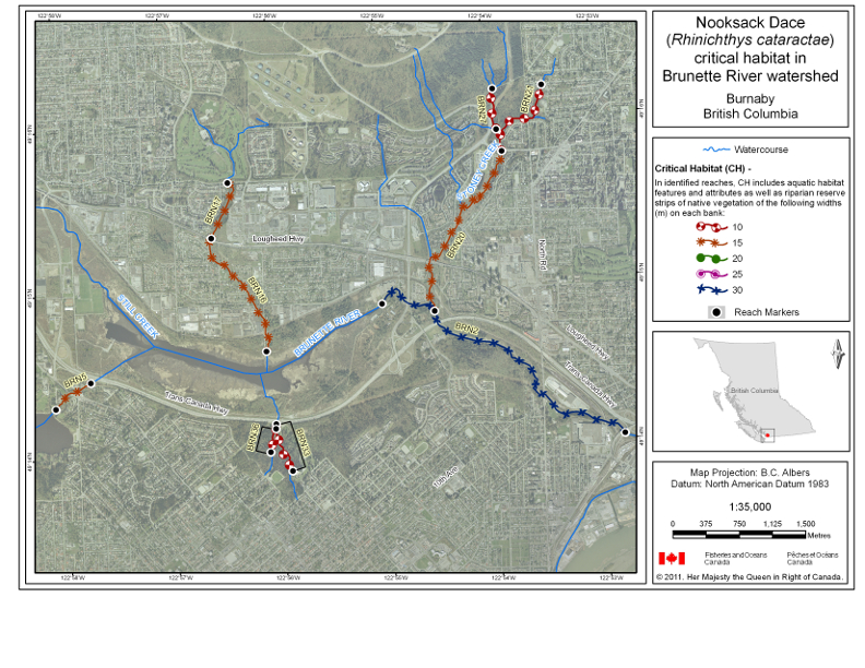
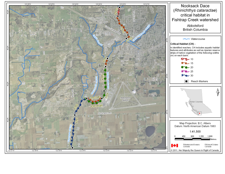
2 (1) For greater certainty, section 1 applies to that species’ critical habitat, which is located within the Bertrand Creek, Brunette River, Fishtrap Creek and Pepin Creek (also known as Pepin Brook) watersheds. More specifically, section 1 applies to the reaches within those watersheds that consist of or are known to have previously consisted of more than 10% riffle by length, to all the aquatic habitats within those reaches, including riffle and shallow pool habitats, and to the riparian reserve strips of native vegetation on both banks of those reaches for their entire lengths, as set out in Table 1 of the schedule and as illustrated in the maps that follow that table.
(2) The critical habitat of the species includes the key features and attributes set out in columns 4 and 5 of Table 2 of the schedule.
Coming into Force
3 This Order comes into force on the day on which it is registered.
SCHEDULE(Section 2)
TABLE 1
Reaches Within the Watersheds and Riparian Reserve Strips that Constitute the Critical Habitat
| Column 1 | Column 2 | Column 3 | Column 4 | Column 5 | Column 6 | |
|---|---|---|---|---|---|---|
| Item | Watershed | Reach CodeFootnote for TABLE 1 Reaches Within the Watersheds and Riparian Reserve Strips that Constitute the Critical Habitat1 | Reach Length (m) | Reach Start Point | Reach End Point | Width of Riparian Reserve Strip of Native Vegetation on Each Bank for Entire Reach Length (m) |
| 1 | Bertrand Creek | BTD1 | 2408 | latitude 49°00′07.96″ N, longitude 122°31′23.89″ W | latitude 49°00′57.54″ N, longitude 122°31′22.84″ W | 30 |
| 2 | Bertrand Creek | BTD2 | 1808 | latitude 49°00′57.54″ N, longitude 122°31′22.84″ W | latitude 49°01′33.71″ N, longitude 122°31′36.06″ W | 25 |
| 3 | Bertrand Creek | BTD3 | 579 | latitude 49°01′33.71″ N, longitude 122°31′36.06″ W | latitude 49°01′43.47″ N, longitude 122°31′43.65″ W | 25 |
| 4 | Bertrand Creek | BTD4 | 1844 | latitude 49°01′43.47″ N, longitude 122°31′43.79″ W | latitude 49°02′15.1″ N, longitude 122°32′02.71″ W | 30 |
| 5 | Bertrand Creek | BTD5 | 652 | latitude 49°02′15.1″ N, longitude 122°32′02.66″ W | latitude 49°02′16.13″ N, longitude 122°31′32.48″ W | 30 |
| 6 | Bertrand Creek | BTD6 | 351 | latitude 49°02′16.17″ N, longitude 122°31′32.57″ W | latitude 49°02′22.54″ N, longitude 122°31′19.8″ W | 30 |
| 7 | Bertrand Creek | BTD7 | 449 | latitude 49°02′22.54″ N, longitude 122°31′19.8″ W | latitude 49°02′28.15″ N, longitude 122°31′02.32″ W | 20 |
| 8 | Bertrand Creek | BTD8 | 1139 | latitude 49°02′28.15″ N, longitude 122°31′02.39″ W | latitude 49°02′30.62″ N, longitude 122°30′12,88″ W | 25 |
| 9 | Bertrand Creek | BTD9 | 1104 | latitude 49°02′30.64″ N, longitude 122°30′12.95″ W | latitude 49°02′13.19″ N, longitude 122°29′32.8″ W | 20 |
| 10 | Bertrand Creek | BTD13 | 356 | latitude 49°02′18.89″ N, longitude 122°28′02.9″ W | latitude 49°02′28.89″ N, longitude 122°27′57.39″ W | 25 |
| 11 | Bertrand Creek | BTD17 | 616 | latitude 49°03′11.45″ N, longitude 122°27′48.88″ W | latitude 49°03′28.69″ N, longitude 122°27′58.91″ W | 15 |
| 12 | Bertrand Creek | BTD18 | 637 | latitude 49°03′28.65″ N, longitude 122°27′59″ W | latitude 49°03′33.6″ N, longitude 122°28′23.27″ W | 20 |
| 13 | Brunette River | BRN2 | 3702 | latitude 49°14′01.47″ N, longitude 122°52′48.62″ W | latitude 49°14′52.46″ N, longitude 122°55′00.98″ W | 30 |
| 14 | Brunette River | BRN5 | 517 | latitude 49°14′27.77″ N, longitude 122°57′45.31″ W | latitude 49°14′18.66″ N, longitude 122°58′05.36″ W | 15 |
| 15 | Brunette River | BRN16 | 1615 | latitude 49°14′36.82″ N, longitude 122°56′06.59″ W | latitude 49°15′19.07″ N, longitude 122°56′34.77″ W | 15 |
| 16 | Brunette River | BRN17 | 725 | latitude 49°15′19.07″ N, longitude 122°56′34.77″ W | latitude 49°15′39.14″ N, longitude 122°56′24.4″ W | 15 |
| 17 | Brunette River | BRN20 | 2362 | latitude 49°14′49.05″ N, longitude 122°54′31.94″ W | latitude 49°15′46.53″ N, longitude 122°53′50.68″ W | 15 |
| 18 | Brunette River | BRN21 | 1052 | latitude 49°15′46.52″ N, longitude 122°53′50.66″ W | latitude 49°16′10.32″ N, longitude 122°53′26.92″ W | 10 |
| 19 | Brunette River | BRN27 | 500 | latitude 49°15′54.63″ N, longitude 122°53′53.26″ W | latitude 49°16′09.6″ N, longitude 122°53′54.38″ W | 10 |
| 20 | Brunette River | BRN33 | 665 | latitude 49°14′10.05″ N, longitude 122°56′02.82″ W | latitude 49°13′52.55″ N, longitude 122°55′54.79″ W | 10 |
| 21 | Brunette River | BRN36 | 279 | latitude 49°14′08.29″ N, longitude 122°56′03.09″ W | latitude 49°13′59.85″ N, longitude 122°56′06.6″ W | 10 |
| 22 | Fishtrap Creek | FTP1 | 1984 | latitude 49°00′08.09″ N, longitude 122°24′24.82″ W | latitude 49°01′02.45″ N, longitude 49°01′02.45″ W | 30 |
| 23 | Fishtrap Creek | FTP2 | 1239 | latitude 49°01′02.63″ N, longitude 122°24′14.62″ W | latitude 49°01′29.22″ N, longitude 122°23′42.31″ W | 30 |
| 24 | Fishtrap Creek | FTP3 | 962 | latitude 49°01′29.15″ N, longitude 122°23′42.18″ W | latitude 49°01′27.53″ N, longitude 122°23′04.31″ W |
|
| 25 | Fishtrap Creek | FTP4 | 460 | latitude 49°01′27.56″ N, longitude 122°23′04.36″ W | latitude 49°01′40.21″ N, longitude 122°22′57.51″ W | 20 |
| 26 | Fishtrap Creek | FTP5 | 1300 | latitude 49°01′40.18″ N, longitude 122°22′57.51″ W | latitude 49°02′20.63″ N, longitude 122°22′50.49″ W | 20 |
| 27 | Fishtrap Creek | FTP6 | 458 | latitude 49°02′20.65″ N, longitude 122°22′50.35″ W | latitude 49°02′34.05″ N, longitude 122°22′44.6″ W | 15 |
| 28 | Fishtrap Creek | FTP10 | 282 | latitude 49°03′05.78″ N, longitude 122°21′54.74″ W | latitude 49°03′11.49″ N, longitude 122°21′50.08″ W | 15 |
| 29 | Fishtrap Creek | FTP11 | 1251 | latitude 49°03′11.49″ N, longitude 122°21′50.08″ W | latitude 49°03′43.72″ N, longitude 122°22′13.03″ W | 15 |
| 30 | Fishtrap Creek | FTP12 | 476 | latitude 49°03′43.7″ N, longitude 122°22′13.07″ W | latitude 49°03′58.17″ N, longitude 122°22′07.89″ W | 10 |
| 31 | Pepin Creek | PEP1 | 191 | latitude 49°00′08.34″ N, longitude 122°28′26.11″ W | latitude 49°00′08.57″ N, longitude 122°28′16.9″ W | 20 |
| 32 | Pepin Creek | PEP2 | 926 | latitude 49°00′08.57″ N, longitude 122°28′16.9″ W | latitude 49°00′34.25″ N, longitude 122°28′14.93″ W | 15 |
| 33 | Pepin Creek | PEP5 | 540 | latitude 49°00′41.61″ N, longitude 122°28′06.16″ W | latitude 49°00′47.19″ N, longitude 122°27′41.86″ W | 30 |
| 34 | Pepin Creek | PEP8 | 326 | latitude 49°01′00.9″ N, longitude 122°26′35.68″ W | latitude 49°01′03.37″ N, longitude 122°26′22.49″ W | 30 |
| 35 | Pepin Creek | PEP17 | 669 | latitude 49°01′01.29″ N, longitude 122°26′29.16″ W | latitude 49°01′20.22″ N, longitude 122°26′28.5″ W | 20 |
| 36 | Pepin Creek | PEP18 | 263 | latitude 49°01′20.22″ N, longitude 122°26′28.5″ W | latitude 49°01′27.43″ N, longitude 122°26′30.39″ W | 10 |
Return to footnote 1See maps.
Maps
Map 1: Critical Habitat — Bertrand Creek Watershed
Map 2: Critical Habitat — Brunette River Watershed
Map 3: Critical Habitat — Fishtrap Creek Watershed
Map 4: Critical Habitat — Pepin Creek Watershed
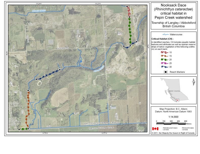
TABLE 2
Key Features and Attributes of the Critical Habitat
| Column 1 | Column 2 | Column 3 | Column 4 | Column 5 | |
|---|---|---|---|---|---|
| Item | Geographic Location | Life Stage | Function | Features | Attributes |
| 1 | Reaches within Bertrand Creek, Brunette River, Fishtrap Creek and Pepin Creek watersheds | Adult and juvenile | Spawning, nursery, rearing and feeding | Riparian habitat |
|
| 2 | Reaches within Bertrand Creek, Brunette River, Fishtrap Creek and Pepin Creek watersheds | Adult | Spawning (April – July) | Riffle habitat |
|
| 3 | Reaches within Bertrand Creek, Brunette River, Fishtrap Creek and Pepin Creek watersheds | Juvenile | Nursery and rearing | Shallow pool habitat |
|
| 4 | Reaches within Bertrand Creek, Brunette River, Fishtrap Creek and Pepin Creek watersheds | Juvenile | Feeding | Shallow pool habitat |
|
| Adult and juvenile | Riffle habitat |
|
Page Details
- Date modified: